Why Does Quantabacook Flood?
Lake Quantabacook floods because, during large, widespread rain events, water flows into the lake from all directions and it has no way to exit the lake.
Normally, Quantabacook has two significant inflows; Ruffingham Meadows and the outflow from Lawry Pond.
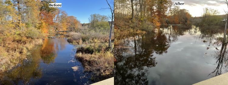
Here are photos and videos that show Ruffingham before and after the heavy rainfall in the early morning of October 31, 2021.
And here’s a look at the flow from Lawry Pond on it’s way to enter Quantabacook just above the dam.
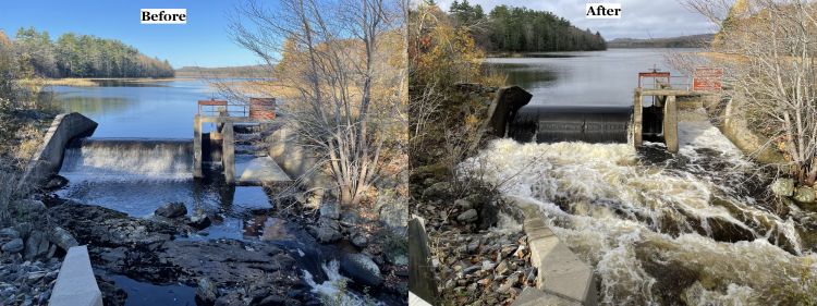
Normally, water from Quantabacook, flows downstream under Bridge #3721 on Rte 131 and then merges with the St. George River. However, after heavy rains, the water level in the St. George River rises and causes the outflow from Quantabacook to reverse and flow back into the lake. Here are photos and videos that show the transformation.
Here’s how things looked before the storm. Near the middle of this video, you can see the water flowing into the bridge opening.
The day after the storm though, the water is flowing from left to right instead of it’s normal right to left. This is true even though there is plenty of capacity available under the bridge. Therefore, the bridge is not the obstruction to the outflow.
Below is a video that shows the water flows backward at the dam as well. It should be flowing from left to right but it’s flowing from right to left instead.
With water flowing in from all directions, Leslie’s wetlands below the dam fill up quickly and then the whole lake rises and a flood results.

The water flow does return to normal fairly quickly. After this event, the water was flowing downstream once again by the next day.
How often does this happen?
Scott Craig of the US Fish and Wildlife Service checked the water flows at the USGS Ducktrap River Measurement Station. By comparing the measured flow for this event against the historical data, he determined that these flood events occur about every 2 years.
What is the impact of the flooding?
Flooding impacts our property and environment in a few ways.
- Flooding poses a threat to property around the lake. While this event didn’t flood camps, we have many reports from property owners of substantial amounts of water inside their camps after previous events.
- Usually, these events happen in the spring. Rapid rises in lake levels at that time can flood the nests of loons and waterfowl in the wetlands around Quantabacook. (Ref: See this map for area wetlands.)
- Backflow from the river might promote the introduction of invasive species from Lake St. George. For example, if milfoil got into Lake St. George, the backflow from the river could carry the milfoil into Quantabacook.
- Looking forward, if climate change causes more frequent and intense weather events, the flooding will get worse.
Next Steps (See Below for Conclusion)
- Continue to document flood events at the lake.
- Identify the constriction point(s) in the St. George River.
- Develop possibilities for widening the constrictions and explore implementing a solution.
Scott Craig of the USFWS has identified some possible constriction points on the river and circled them on this map. Now we need to get photos and videos. Note that areas of the river that are colored in yellow are potential salmon spawning habitat.

Further Findings and Conclusion
On Friday November 12, 2021, Scott Craig poled and paddled from the 131 Bridge to the bridge at Ghent Road.
He reported 3 findings relating to flooding.
- No single constriction point was identified on the St. George.
- No large wood spans or beaver dams obstructed the river. There as one small span and several partials but nothing that would significantly interfere with the water flow.
- There was grass in overhanging limbs more than 3 feet above the river indicating that the river level rises to at least that height during flood events.
Conclusions
What we know now is that, during large rain events, the entire St. George River level rises more than 3 feet. With no single constriction point identified, the flooding is caused by insufficient capacity the whole length of the river as far a Ghent Road, which is well over a mile long.
In other words, the action required to address the flooding would be to widen the river bed for the whole length of the river to Ghent Road and maybe beyond. Intuitively, such a project is not feasible from either a cost/benefit standpoint or an environmental one.
Based on this data, we need to plan for the flooding to continue and the Lake Association will continue to document flood events to aid in this planning.
Special thanks to Scott Craig, Leslie Thomas and Don Berry for their support in documenting this issue.
